Want to read stories like this sooner? Subscribe to the North Carolina Rabbit Hole for free.
Some people, it seems, were highly aware of a commercial during the Super Bowl in which Bruce Springsteen travels to the geographical center of the United States to talk about gettin’ along and selling Jeeps or something.
Politics aside, you might be thinking, what exactly do you find if you travel to the geographical center of North Carolina? Buried treasure? The bones of George III? Pikachu?
That’s a tricky question because, depending on who you listen to, there are at least THREE places that claim to be the exact middle of this state. The most famous is the town of Star, which bases its claim on calculations made by the Army Corps of Engineers. Some time ago, WRAL’s Scott Mason went out and visited the exact site, which consisted of a plaque and a state geodetic marker out behind some chicken houses just northwest of town. All of this stuff is on a private farm, so it’s not a place that you can just stop by and visit.

I looked for, but couldn’t find, that geodetic marker in the state’s database. Nor could I find anything from the Corps that defined the exact point. A former mayor told Mason he remembered talking to someone from the Corps about the measurement being made at 4:20 p.m., because that’s when the satellite was in the right position. The story didn’t just come from nowhere. And, you can see in the date and the coordinates, there’s an exactness that seems to lend credence to this.
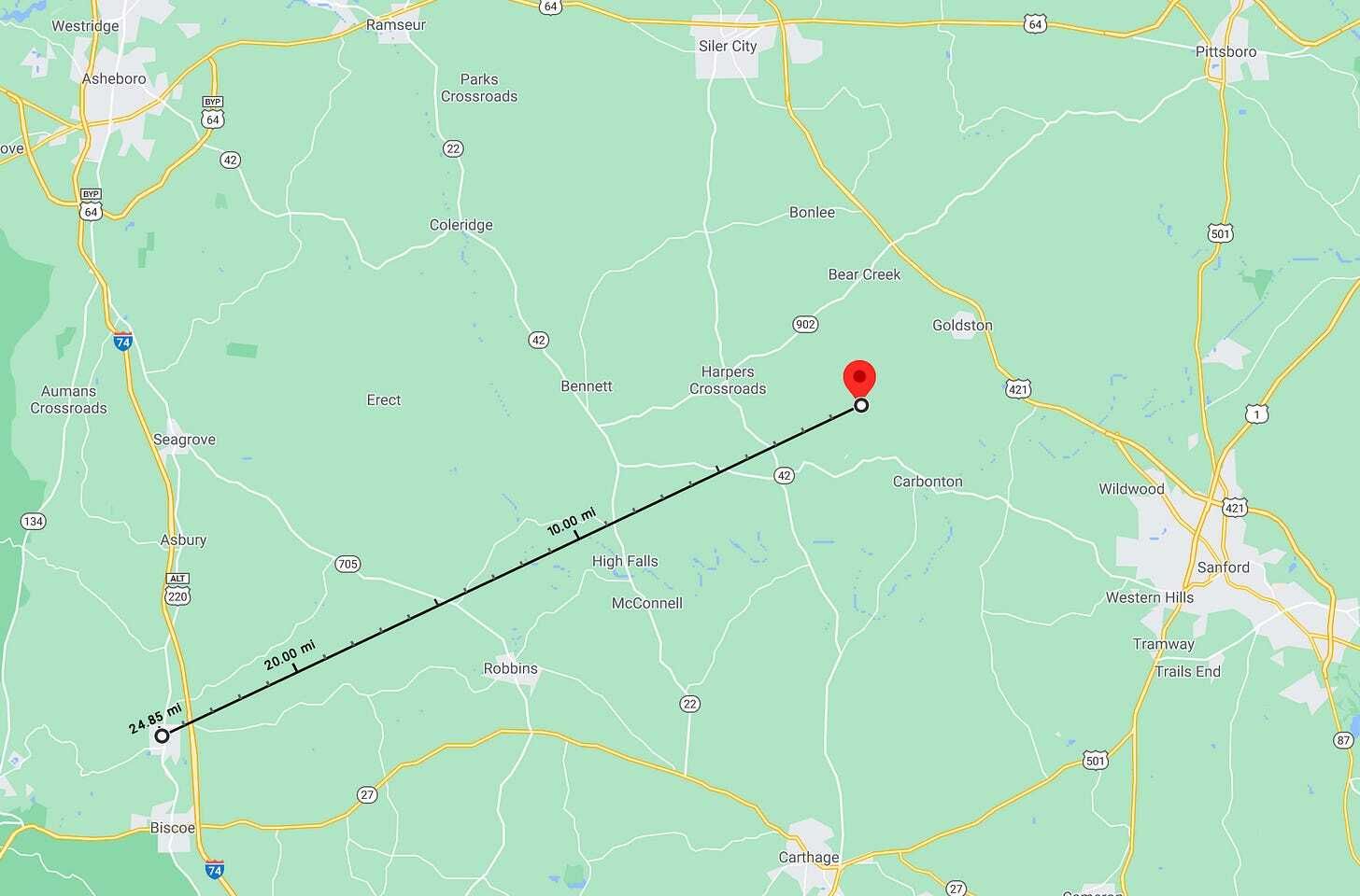
I have no reason to doubt the good people of Star. However! (Ducks from debris being thrown at me from kindly Montgomery County folk.) The U.S. Geological Survey sees things differently. It places the geographical center much closer to the town of Sanford. The “exact” spot, if you will, is about 25 miles to the east of Star, out in, you guessed it, another farm field.

Before I go on, there’s a third place that’s kind of defined as the center: Purgatory Mountain. This comes to us via the “Only In Your State” folks, who don’t back this up with any links or documentation. But, hey, you can stop by whenever you’re at the zoo.
All of this is, um, subjective. An old pamphlet from the Department of the Interior says as much:
There is no generally accepted definition of geographic center, and no completely satisfactory method for determining it. Because of this, there may be as many geographic centers of a State or country as there are definitions of the term. The geographic center of an area may be defined as the center of gravity of the surface, or that point on which the surface of the area would balance if it were a plane of uniform thickness.
So, maybe you draw a line on a globe between, approximately, Murphy and Manteo, and then another one that lines up with the southernmost and northernmost points, and you get your answer. Or you do like the pamphlet suggests, and try to balance a cutout of North Carolina on the head of a pin. Either way, it’s an imperfect way to measure. And, as you might guess, trying to divine some meaning from an arbitrary place that’s defined by arbitrary boundaries can leave you scratching your head a little bit.
I say this as someone who has visited the most remote place in North Carolina. In my case, that place was defined by Project Remote as the spot that was furthest away from a road. In this state, that’s a point some 5.5 direct miles away from the end of the Road to Nowhere in the Great Smoky Mountains National Park. It took me and two others about a day and a half to get there. We found … nothing, and then hiked back.

But because people have now visited this place and called it The Most Remote Spot, it now has at least some meaning. News stories have been written about it. I put together a piece about it in Our State and, before that, made it the subject of my very first episode of Away Message. Those two things caused people to contact me, asking if I can tell them how to get there.
(Before you ask, I calculated the spot using the information that was publicly posted by Project Remote. Ryan and Rebecca Means, the very nice and helpful folks who run it, didn’t give out the exact coordinates. The reason: They didn’t have the explicit blessing of the Great Smoky Mountains National Park. Yes, the spot is on public land, but rangers strongly encourage you not to go off-trail in the park, which is what we did to reach it.)
And yet, what if another group were to define remoteness differently? What if Project Remote changed its calculations? What if someone were to build a road nearby? If those things happened, the exact point would move and that physical spot would lose all meaning.
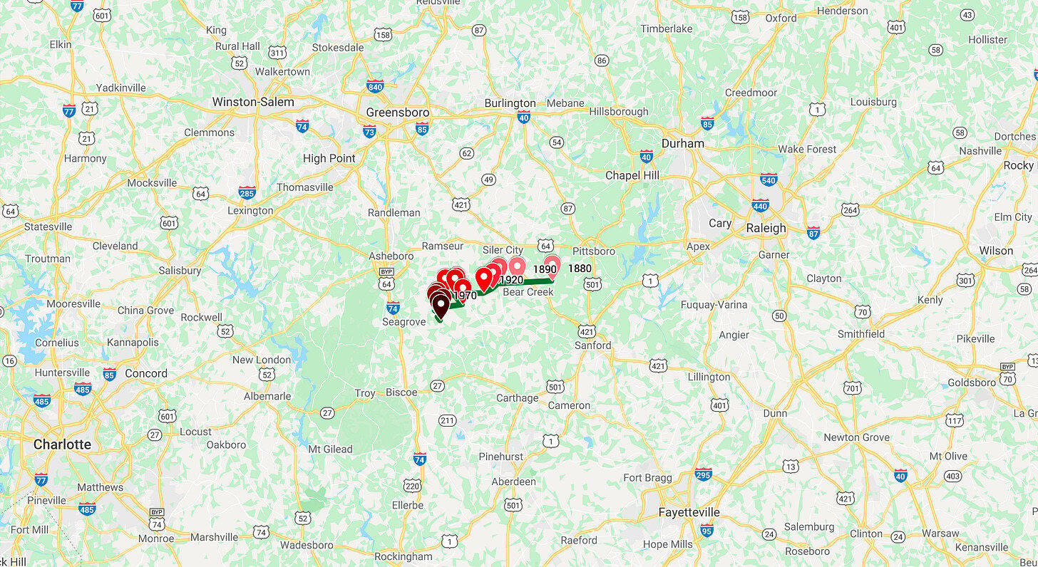
Which is exactly what happens every ten years to another “exact” point: North Carolina’s center of population. Back in the early days of this state, that point was very close to the coast, since that’s where all of the state’s largest cities were. (New Bern was once the capital, if you didn’t already know.) But, thanks to canals, railroads, and eventually highways, the population was able to move inland. The U.S. Census has tracked the center of North Carolina’s population since 1880, and I’ve charted it on a Google Map. It’s interactive, and you can click here to check it out.

The center keeps moving westward, and it’s also moved a little to the south as well. Today, it’s located in rural Randolph County, near a spot that bears the name Erect, North Carolina. Hold on, one moment.

Anyway, the current population center is in the middle of some woods near (chortles) Erect, which, yes, you can travel to, but no, you won’t find anything when you get there.
That’s the point: A point is… just a point. In your town, you could define the center as downtown. Or, maybe, a brewery. Perhaps your most popular restaurant. It could be a church. Maybe it’s a park where everyone gathers, or a meeting spot that’s easy to get to for you and your friends. Politically, maybe you see the center as bipartisanship. Or, maybe, it’s the suburbs which sit in the middle of an urban-rural divide that keeps growing. Even the middle of nowhere isn’t the middle of nowhere for the people who live nearby. It’s all subjective. So, sure, you could have sent, say, the late Andy Griffith to a farm field in North Carolina to wax poetic about finding common ground. But in reality, you would have had to catch him when he wasn’t busy filming ads for Bev Perdue and Mike Easley.
—
I, Jeremy Markovich, am a journalist, writer, and producer based outside of Greensboro, North Carolina. If you liked this, you might like Away Message, my podcast about North Carolina’s hard-to-find people, places, and things. Season 4 was all about the Mountains-to-Sea Trail.
Author avatar by Rich Barrett.
If you enjoyed this edition of the North Carolina Rabbit Hole, share it with your friends and mash that subscribe button below.
